


聚光灯
地理信息系统分析员(GIS 分析员)、地理信息系统管理员(GIS 管理员)、地理信息系统分析员(GIS 分析员)、地理信息系统协调员(GIS 协调员)、地理信息系统技术员(地理信息系统技术员)、资源分析员、遥感专家、地理空间数据科学家、地理空间解决方案架构师、地理信息工程师
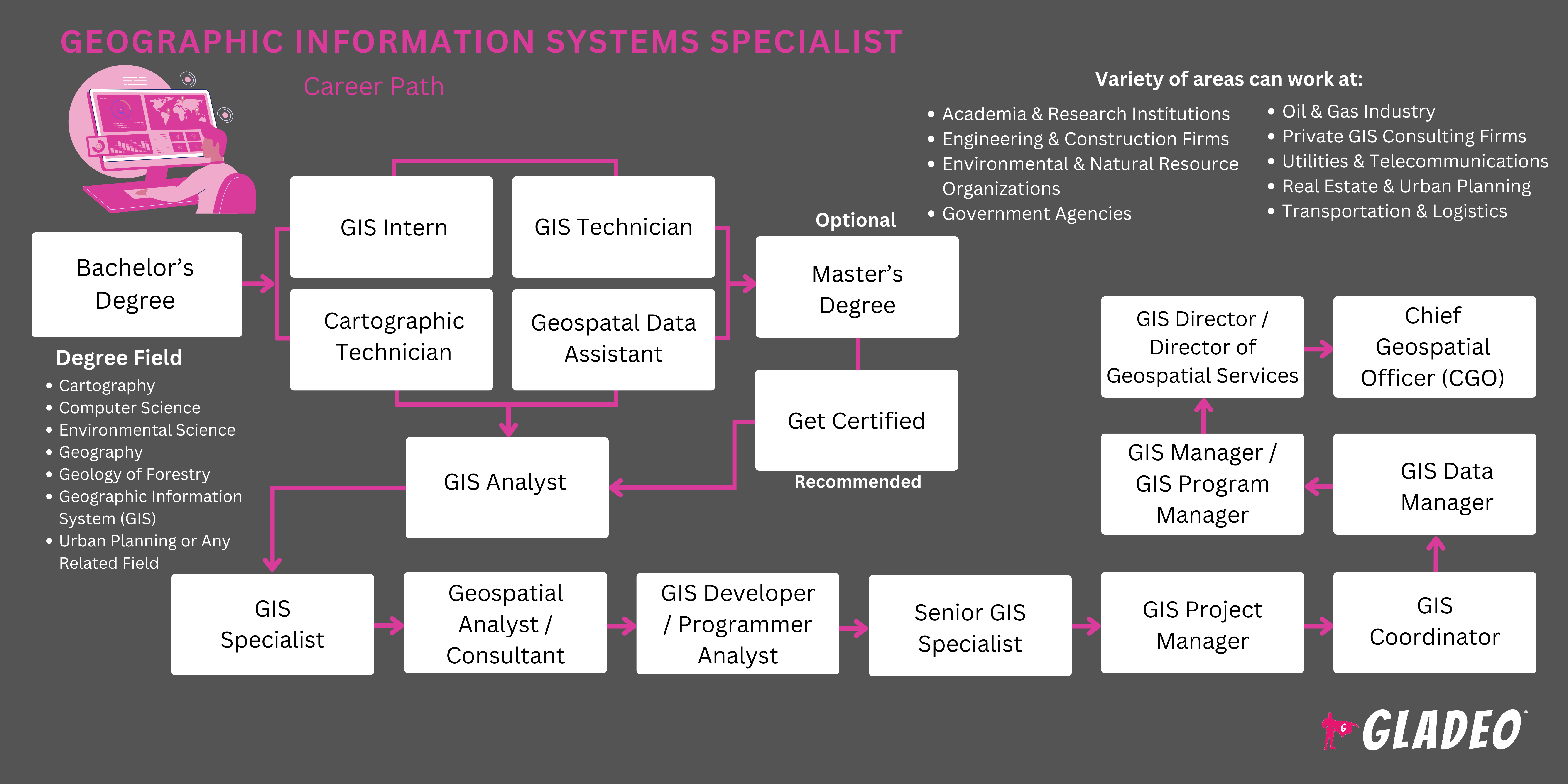
地球表面是一个迷人的研究领域,但在收集和理解有关它的数据方面有无数的挑战。这就是为什么计算机科学家创造了地理信息系统(GIS)来帮助捕捉、检查和显示各种来源的数据。从山脉到郊区街道,GIS程序提供的信息可用于成千上万的应用。但是需要训练有素的专家--被称为地理信息系统专家--来正确使用这些复杂的计算机系统。
GIS专家的职责可能涉及设计或开发GIS系统和数据库,然后利用这些系统和数据库来帮助科学家和研究人员开展各种需要某些地点的地理空间数据的项目。通过将数据输入制图程序,他们可以创建和定制包含各种信息的地图。这种可能性实际上是无穷无尽的,但有几个例子:显示人口和民主统计数据的地图,显示野生动物栖息地的地图,以及显示难以到达的地形特征的地图。
GIS技术被地方政府用于公共工程、规划和环境管理,以及财产记录。它也被房地产、公共安全、国防、交通、健康管理、自然资源开采和其他一些领域所依赖。许多人认为 谷歌地图是一个地理信息系统,它与GPS(全球卫星定位)连接,提供免费的导航服务。
- 帮助捕捉和利用地理空间数据以达到规划目的
- 为成千上万的组织提供改善运营的工具,使其有能力。
- 保障人类工人免受人工测绘的劳动和危险的影响
工作日程
- 地理信息系统专家通常是全职工作。在某些情况下,当工作紧急时需要加班。有些人可能只在需要的情况下从事兼职工作。
典型职责
- 讨论项目范围、预期、预算、时间表和责任
- Stay knowledgeable on a vast array of project types, including those involving civil engineering, electrical engineering, surveys, solar and wind energy, land development for residential and commercial use
- Research methods and places from which to gather data
- 收集和评估来自各种经批准来源的数据,如远程传感器
- 根据需要,与外地支持人员进行联络
- 设计并帮助建立综合计算机系统、数据库、建模程序和科学/数学模型
- 根据需要,修改现有的地理信息系统数据库
- 对GIS程序进行编码,进行功能测试,并对错误进行排查
- 对地理信息系统的改进、升级和其他变化提出建议
- 维护工作流程的技术文件
- 准备并向数据库输入数据。评估已经加载的现有数据
- 运行数据分析并注意到趋势和模式
- 进行地理空间建模和分析
- Review aerial photos and orthoimages
- 决定在报告中使用适当的地图元素
- Use GIS to prepare reports, graphics, tables, data layers, 3D
renderings, maps, etc. - 为客户或利益相关者解释结果
- 与相关工作人员或团队合作;讨论调查结果
额外责任
- 研究GIS与全球定位系统软件的工作方式
- 从事地理信息系统移动应用程序的工作
- 确保质量控制和数据的准确性
- 为用户提供培训和技术支持
- 了解行业变化和技术进步的最新情况
- 参加专业组织的活动,分享信息并向他人学习
软技能
技术技能
- 基本工程原则和程序
- 计算机辅助设计(CAD)程序
- 数据分析软件
- 数据库管理系统
- 设计软件、蓝图、3D模型、技术计划
- 开发环境软件
- 企业资源规划
- Geographic information systems, such as ESRI ArcGIS
- Geospatial industry programming languages, including Python, JavaScript, C+, HTML/CSS, Swift, Java, C#, SQL, PHP, Rust, Lotlin, Ruby, TypeScript, Matlad, Go, etc.
- Google Earth, KMZ files, and lidar
- 图形/照片成像程序
- Map creation software like CDA International’s Manifold System or ITT Visual Information Solutions
- 移动定位服务软件
- 曾从事/熟悉咨询工程师和/或测量师的工作
- Scientific software, such as Coordinate Geometry COGO
Understanding of geography
- 银行
- 市、州和联邦机构
- 土木工程公司
- 商业企业和工厂
- 通信系统安装供应商
- 教育和研究机构
- 环境科学机构
- 火灾报警/安全系统安装人员
- 林业服务
- 保健和人类服务机构
- 暖通空调安装人员
- 保险公司
- 执法机构
- 政治学团体
- 房地产机构
- 零售企业
- 供应链管理公司
- 城市规划师
- 公用事业供应商
GIS technology is, or can be, used in virtually every industry imaginable! To get a feel for just how reliant we’ve become on these critical systems, check out Nobel’s 20 Ways GIS Data is Used in Business and Everyday Life. GIS is a core asset used to make important decisions that impact everything from company profits to public safety. Because of our dependence on GIS, GIS-generated data and results must be as accurate as possible.
GIS Specialists are the key to making sure the systems perform as needed and provide trustworthy output. A dated example of GIS gone wrong was pointed out on Stack Exchange, which noted how the incorrect use of spatial aspects completely misrepresented the “potential reach of North Korea’s missiles.” One simple oversight caused The Economist to report a massive underestimation of a possible military threat’s true scope.
The field of GIS was born in the early 1960s and has developed nonstop ever since. Current trends include the increasing use of 3D analysis to add value to projects. Another area seeing exciting change is Web GIS, which brings the power of these systems to much larger communities. This, in turn, is expanding opportunities, enticing more people to learn GIS skills and add to the advancement.
In addition, the integration of GIS with Building Information Modeling and Computer-aided Drafting and Design is transforming and expanding the capabilities of these systems. Of course, as with so many other fields, Artificial Intelligence and Machine Learning have entered the fray to tap into the full potential of GIS while drawing upon real-time and “big” data.
上述每一个趋势都是如此广泛,以至于没有一个GIS专家能够全部研究它们,但最好是熟悉所有正在发生的变化和创新。
Geographic Information Systems Specialists probably loved working with computers at an early age. They might have taken an interest in how things work or in data, statistics, figures, and even trivia. They may also have enjoyed using software to create art or graphic designs. Future specialists may have had a strong interest in some particular field, such as environmental studies, that they wanted to improve with the use of GIS technology.
- GIS专家需要至少有GIS、地理或环境研究方面的本科学位
- 如果学生有足够的相关GIS经验,其他相关专业也可以考虑。
- Students will need to learn how to use various software programs such as Esri ArcGIS Desktop suite for advanced analytics, 2D and 3D, image processing, advanced visualization, connecting and sharing, and data management
- 其他学习主题包括。
- AutoCAD and DWG files
- 制图方法、理论和原则
- 坐标几何学COGO
- 协调系统
- 地理数据库
- GIS scripting languages like Python, JavaScript, C+, HTML/CSS, Swift, Java, etc.
- Google Earth and KMZ files
- GPS数据收集和管理
- LiDAR数据集
- Map creation software like CDA International’s Manifold System or ITT Visual Information Solutions
- 图形文件
- 矢量和栅格数据集
- GIS专家有几个国家认证,包括。
- Adobe Systems Incorporated - Adobe Campaign Classic Business Practitioner Expert Certification
- American Society for Photogrammetry & Remote Sensing - Imaging & Geospatial Information Society -
- Certified GIS/LIS Technologist
- Certified Mapping Scientist - UAS
- Certified Mapping Scientist Lidar
- Certified UAS Technologist
3. Environmental Systems Research Institute -
- ArcGIS API for JavaScript
- ArcGIS Desktop Associate 10.5
- ArcGIS Desktop Entry 10.5
- ArcGIS Desktop Professional 10.5
- Enterprise Administration Associate 10.5
- Enterprise Geodata Management - Associate 10.5
- Enterprise Geodata Management - Professional 10.5
- Enterprise System Design Associate 10.5
4. GIS Certification Institute - Geographic Information Systems Professional
5. National Geospatial-Intelligence Agency -
- Professional Certification Applied Science
- Professional Certification Fundamentals
- Professional Certification GEOINT Collection
- Professional Certification Geospatial Analysis
- Professional Certification in Geospatial Data Management
- Professional Certification in Human Geography
- Professional Certification Imagery Analysis
- Professional Certification Maritime
6. United States Geospatial Intelligence Foundation -
- Certified GEOINT Professional- GIS & Analysis Tools
- Certified GEOINT Professional- Remote Sensing & Imagery Analysis
- Certified GEOINT Professional- Geospatial Data Management
7. WorldatWork - Certified Benefits Professional
- 考虑学费、折扣和当地奖学金的机会(除联邦援助外)。
- 在决定是否报名参加校内、网上或混合课程时,要考虑你的时间安排和灵活性。
- 查看该项目教师的奖项和成就,看看他们都做了哪些工作
- 仔细观察他们的教学设施以及他们让学生训练的设备和软件。
- 查看就业安置统计资料和该项目校友网络的详细信息
- 高中课程,如计算机科学、计算机编程、地理和经济学,可以帮助学生为地理信息系统的大学课程做好准备
- Consider applying for a GIS-related apprenticeship
- 如果你有能力,尝试通过兼职工作获得一些工作经验,让你获得技能和实践。
- 写下和你一起工作的人的名字和联系方式,因为他们有一天可能会成为未来的工作推荐人。
- 研究与GIS技术的许多应用有关的书籍、文章和视频教程。试着确定你毕业后想在哪个领域工作
- 询问一些经验丰富的GIS专家,你是否可以跟随他们,了解他们的日常活动。
- Join professional organizations like the National Geospatial-Intelligence Agency to learn about trends and grow your network
- 获得一个专业领域的认证,以加强你的证书
- 志愿参加学校活动,你可以学习如何有效地作为一个团队工作,练习你的软技能,并管理项目
- 不要等待开始起草你的简历。把你学会使用的软件和设备记录下来,这样你就不会迷失方向。
- 通过查看Indeed和其他招聘门户网站上的招聘信息,提前审查工作标准。
- GIS-related apprenticeships may be a good way to break into this line of work
- 在申请前尽可能多地积累经验
- Set up alerts on job portals such as Indeed, Simply Hired, Glassdoor, and Zippia
- 仔细阅读广告,确保你符合所有申请条件
- 联系在职的GIS专家,询问他们是如何得到工作的。
- 让你的网络知道你已经开始找工作了,这样他们就可以提醒你有职位空缺。
- 向你学院的课程或职业中心寻求求职方面的帮助。
- 许多项目作为招聘人员的管道,所以要让他们知道你已经准备好工作了!
- Review GIS Specialist resume templates to get ideas for wording and formats
- 在简历上列出所有的教育、技能、培训和工作经历,并请朋友或编辑审查
- 问问以前的老师和主管,他们是否愿意作为个人推荐人。
- Study GIS Specialist interview questions to prep for interviews!
- Hop on Quora and start asking job advice questions
- 要想面试成功,着装一定要得体!
- Stay on top of the game by constantly improving your skills and learning new things through online courses such as Bootcamp GIS’ Agile Management of a Modern GIS
- 完成硕士学位或高级认证,使你有资格获得更高层次的权力
- 与同行交流地理信息系统的新发展和用途
- Demonstrate thought leadership and help your employer use their GIS to the maximum benefit
- 学习如何有效地沟通你所带来的好处
- Build trust by being accountable, meeting deadlines, and ensuring accurate, high-quality results
- 勤奋研究,从可靠来源收集数据
- 尊重每一个人,建立你作为一个专业人员的诚信的声誉
- 对能力要透明,并提供可行的解决方案
- 观看并向更多资深GIS专家学习。提出问题并记下最佳做法
- 在社区和通过增加对专业组织的参与来扩大你的专业网络
- 尝试赢得奖项和认可,这在你的简历上会很好看。
- 与你的上司进行坦诚的讨论。如果你的雇主没有晋升的机会,请考虑你是想留下还是转行
网站
- Adobe Systems Incorporated
- 美国地理学家协会
- 美国摄影测量与遥感学会--影像与地理空间信息学会
- 美国摄影测量和遥感协会
- 环境系统研究所
- 地理空间信息和技术协会
- GIS认证机构
- National Geospatial-Intelligence Agency
- 全国各州地理信息委员会
- 美国地理空间情报基金会
- URISA
- 世界在工作
书籍
- A Primer of GIS, Second Edition: Fundamental Geographic and Cartographic Concepts, by Francis Harvey
- GIS For Dummies, by Michael N. DeMers
- Imagery and GIS: Best Practices for Extracting Information from Imagery, by Kass Green, Russell Congalton, et al
- Learning Geospatial Analysis with Python: Understand GIS fundamentals and perform remote sensing data analysis using Python 3.7, by Joel Lawhead
O*Net lists the following related occupations to think about!
- 制图师和摄影测量师
- 数据科学家
- 大地测量师
- 软件开发人员
- 测绘技术员
新闻联播

特色工作
在线课程和工具